Dahua Technology’s AI-based Remote Sensing Image Analysis Technology has obtains first place in the comprehensive precision ranking of the Onera Satellite Change Detection (OSCD) Evaluation released by Geoscience and Remote Sensing Society (GRSS). This achievement demonstrates Dahua Technology’s continuous development and innovation capabilities in the field of remote sensing image change detection.
OSCD IEEE IADF TC recognition
OSCD (Onera Satellite Change Detection) is jointly issued and maintained by the International Institute of Electronics and Electrical Engineers (IEEE), and the Image Analysis and Data Fusion Technical Committee (IADF TC). It is an international authoritative evaluation platform for remote sensing image change detection algorithm.
This evaluation involves complex and variable global surface coverage data, which is extremely challenging and attracts scholars and well-known academic institutions across the globe to participate.
The innovative use of the Tversky loss function optimizes the problem of category imbalance
Multi-channel fusion in data processing
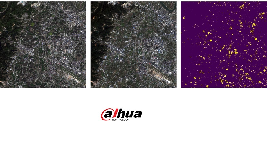
In view of the large size of remote sensing images and the imbalance in the types of changing areas, Dahua Technology proposed a method of image stretching and normalization preprocessing based on multi-channel fusion in data processing, which significantly solves issues including obvious surface differences.
In terms of model structure, the innovative use of the Tversky loss function optimizes the problem of category imbalance. At the same time, Dahua Technology innovatively builds multi-modality and greatly improves the precision and recall of its algorithm. The Dahua Remote Sensing Image Analysis Technology has set another evaluation record in the remote sensing image change detection data set, achieving first place in the overall ranking.
City-Level Sensing Image Change Detection
Based on the change detection algorithm of remote sensing images, the Remote Sensing Image Change Detection Technology uses remote sensing images of different phases to obtain the dynamic change information of the land cover type in the specified area, and assigns semantic category labels to image pixels that change with time, which is widely used in ecological resources monitoring, urban construction management and other fields.
Can be applied to acquire coverage information including periodic monitoring of water bodies, vegetation, minerals
In the field of ecological resources monitoring, the remote sensing image change detection algorithm can eliminate interference factors such as season and weather by comparing the remote sensing images of the same area before and after (two time phases) to obtain the spatio-temporal changes in the ecological geology of a wide area.
It can be applied to acquire coverage information including periodic monitoring of water bodies, vegetation, minerals, etc., providing a scientific basis for scenarios such as resource development, environmental pollution, and natural disaster assessment.
Illegal buildings inspection
In the field of urban construction management, the Remote Sensing Image Semantic Segmentation Technology can be used to automatically obtain the location, range, type and other information of the area where the nature of the land changes, achieving a city-level intelligent inspection of illegal buildings.
Extract distribution information of urban infrastructures such as sports venues
At the same time, the Remote Sensing Image Object Detection Technology can be used to effectively extract distribution information of urban infrastructures such as sports venues, dynamically monitors the construction process of infrastructure facilities within the city, and provides effective data support for urban infrastructure auditing.
In addition, the combination of high-altitude and ground monitoring data can achieve the integration of ground, air and sky monitoring coverage without dead angle, providing a comprehensive and high-precision spatial visualization for urban construction management.
Video-centric IoT solution and service provider
Zhejiang Dahua Technology Co., Ltd. is a video-centric smart IoT solution and service provider. With more than 16,000 employees all over the world, Dahua solutions, products, and services are applied in 180 countries and regions. The company ranked 2nd in the “2019 a&s Security 50”. Committed to technological innovations, Dahua Technology continues to explore emerging opportunities based on video IoT technologies with businesses in machine vision, video conferencing systems, professional drones, electronic license plates, RFID, robotics, etc., enabling a safer society and smarter living.